

Prof. LIU Lin
Earth System Science Programme
Our Eminent Scientists @ CUHK:
Uncovering the Cryosphere with Artificial Intelligence
Verkhoyansk, a Siberian town near the Arctic Circle, is one of the coldest towns on earth; it recorded the highest temperature of 38°C on 20th June 2020. The temperature has jumped in recent months to levels rarely seen in the region, and the sign that climate change is transforming weather patterns all over the world has aroused our attention to the cryosphere, the frozen part of the earth system.
Monitoring the cryosphere comprising glaciers, ice caps, sea ice, permafrost, and many more in a sustained manner requires constant effort. Professor LIU Lin, a geophysicist from the Earth System Science Programme, has been thinking of time-saving methods to monitor the rapid changes happening in the world’s cold regions like the Arctic and Tibet. Recently, he has developed the first automated mapping tool using artificial intelligence (AI) to release scientists from tedious observation and monitoring work, and enable them to develop comprehensive cryosphere assessments in an efficient way.
The Cryosphere Crisis
The intensifying global warming has brought irreversible damages to the cryosphere. Though we are living far away from the Arctic, we had also experienced some of the extreme weather events brought by the changes in the cryosphere, such as hotter summers, extreme cold events in winters, or even severe typhoons.
Geophysicists consider all these events as the results of a series of interactions among the earth system. The retreat of glaciers leads to a rise in sea level and poses risks to flooding in the low-lying coastal areas. Hong Kong had experienced flooding in extensive areas before; Venice, Italy’s canal city was also ravaged by severe flooding a year ago.
The melting of frozen-cold water in polar regions also influences the coupled dynamic system formed by the ocean and atmospheric currents; it not only affects the global climate and brings extreme weather, but also threatens the biosphere. When permafrost storing a large amount of organic carbon starts thawing, the content stored will be released in the form of carbon dioxide and methane, a kind of potent greenhouse gases, to the atmosphere. With the thaw, the long-dormant bacteria and viruses trapped in ice and permafrost for centuries revive. A little change in the cryosphere in fact can have ripple effects across the globe, and we are trapped in the vicious circle.
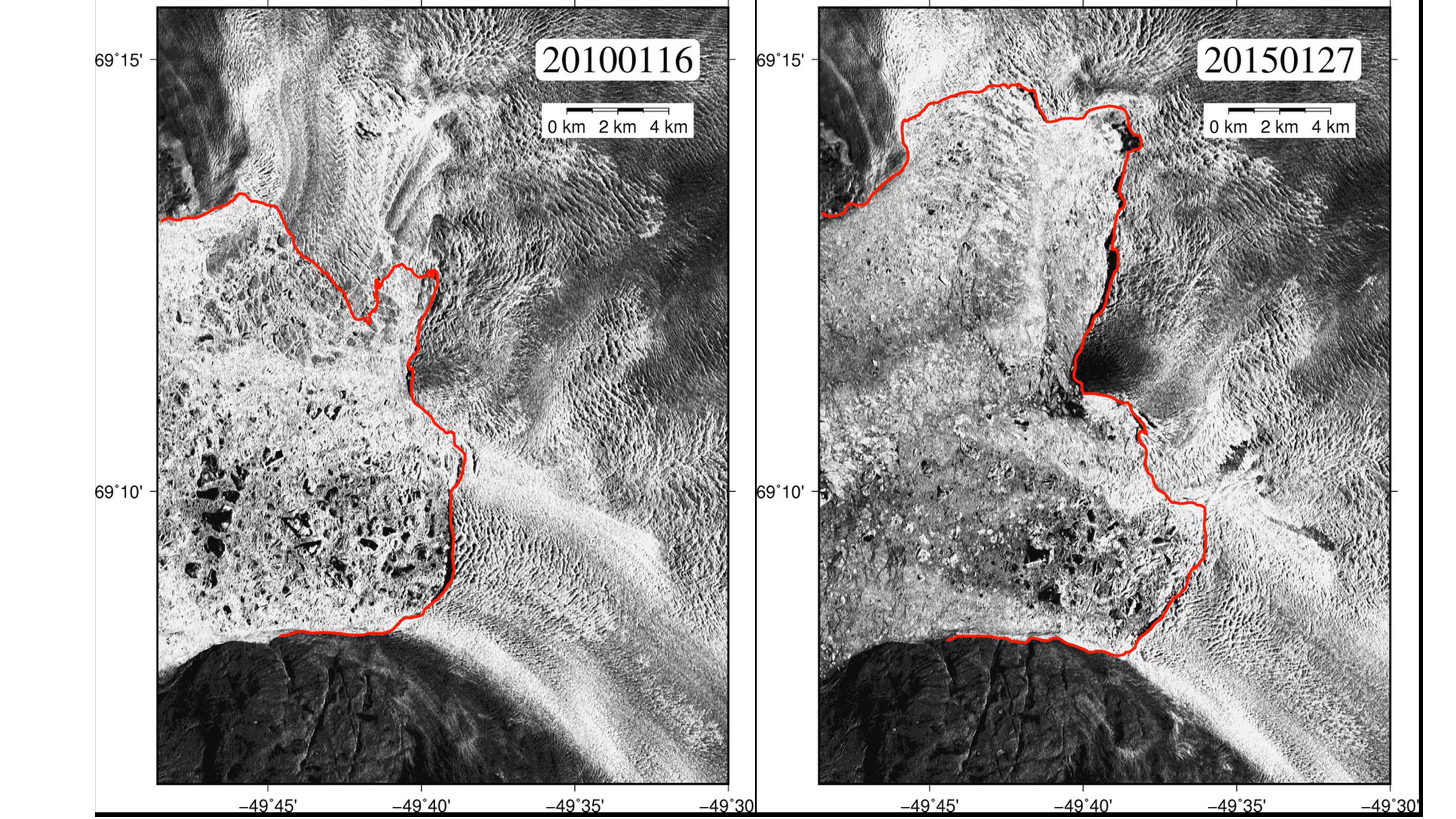
LIU’s team applied the newly developed AI-based tool to analyse the satellite images of Jakobshavn Isbrae, Greenland.
The glacier has significantly retreated in just five years; “Calving Front” (red line), the junction of glaciers and the sea, is important for the stability of the entire ice sheet. (Photo extracted from the interviewee’s video)
Magic Tools for Earth Scientists
Earth scientists seek to understand the interaction among lithosphere, hydrosphere, biosphere, and atmosphere, also known collectively as the earth system. Remote sensing is one of the helpful tools to detect and monitor the physical properties of a designated area. CUHK also has a remote sensing station on campus; the Satellite Remote Sensing Ground Receiving Station, a white globe standing between the top of New Asia College and United College, is the only national satellite remote sensing station in Hong Kong.
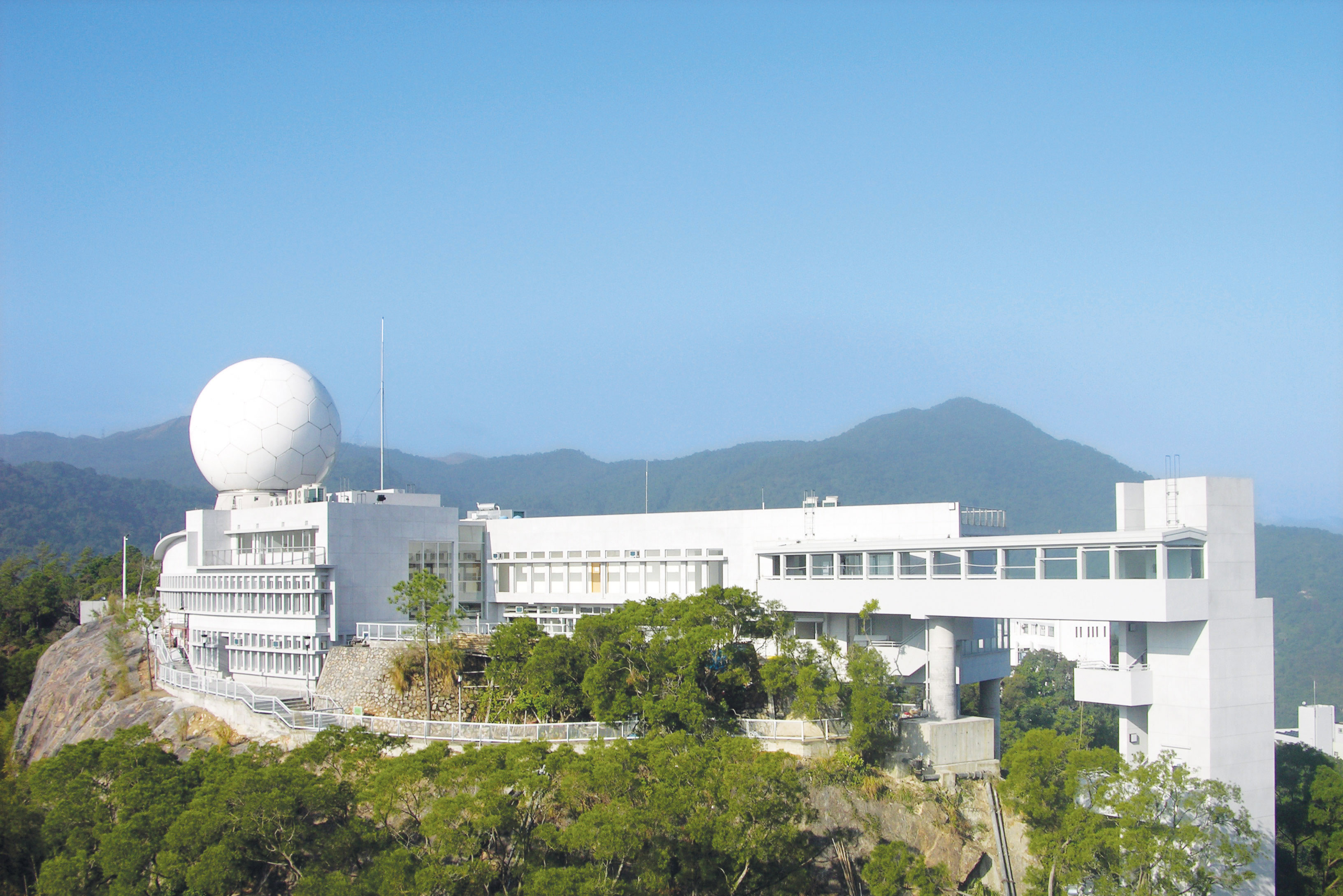
The white globe is the only national satellite remote sensing station in Hong Kong.
There are many constraints on traditional field-based approach to observing and monitoring permafrost thawing. Taking the Tibetan Plateau as an example, it is not easy for scientists to access due to its remoteness and harsh weather conditions. The large coverage of permafrost on site also makes the investigation labor-intensive and time-consuming. Remote sensing-based observation and monitoring can free scientists from such work when studying a wide range of terrains, but it also has limitations on detecting thermokarst, a landscape resulted from permafrost thawing.
AI-driven Thermokarst Monitoring
It is sometimes hard for commonly used software to detect the changes in thermokarst; it is even harder for scientists to analyse them manually due to the vast investigation area. The growing interests of AI application in scientific research inspire LIU to think of a new alternative to the conventional analysis of satellite images. The process of developing an AI-based tool is challenging yet valuable. The long-used AI framework “DeepLab” was developed to interpret daily images such as cats and dogs, resulting in significant errors when examining satellite images. The AI tool that he newly developed requires countless supervised learning to reach automation; it also requires the feeding of a massive amount of satellite images taken over the Tibetan Plateau and endeavours of his group to training and refining the algorithm so that it can learn the thermokarst features. After several rounds of mapping and modelling, the group will also visit the sites at the Tibetan Plateau to verify its efficacy. Though the tool does not give hundred percent of accuracy, it can ease the burden of scientists on analysis work and minimise human errors.
Recently, LIU has published a journal about this revolutionary deep-learning method “DeepThaw”, introducing its capability to analyse and identify more than 200 thermokarst landforms from satellite images. The project was supported by the General Research Fund (GRF) 2019-20 of the Research Grants Council; and the novel automatic monitoring and analytics tool marks a milestone in the application of AI in geomorphology and geophysics. Looking forward, LIU will continue to work on enhancing the tool’s coverage from 1% of the Tibetan Plateau to 10% and beyond.
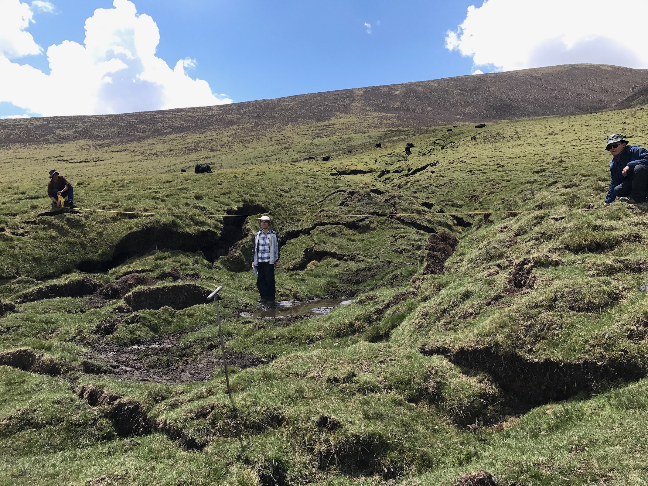
LIU visited the thermokarst at the Tibetan Plateau.
AI highly raises research efficiency and is very likely to replace human hands for those tedious processes. The analysis of permafrost is an obvious example; it takes around ten days for researchers to complete the analysis using the traditional way but the automatic initiative reduces the time to two days. “Some researchers may lose their jobs in the future,” LIU laughed, “scientists can use the spare time to conduct more frequent monitoring on the permafrost changes to better understand the thawing and formation mechanisms, so that we can provide early intervention and have potential threat forecasting.”
Every Effort to Save Our Environment
The Paris Agreement regulating greenhouse gas emissions through joint efforts was launched on the United Nations Framework Convention on Climate Change in 2015. Still, reducing the pace of global warming largely depends on worldwide policymakers. To provide policymakers with regular scientific assessments on climate change, its implications, and potential future risks, the Intergovernmental Panel on Climate Change (IPCC) of the United Nations prepares assessment reports every five to seven years.
LIU makes every effort to save the environment. He and many other scientists actively present their research deliverables to and participate in activities organised by the IPCC, hoping to contribute their expertise. From time to time, we may also see him and his research findings in the media, it is all because he hopes to arouse public awareness of the crisis that the cryosphere is facing, and the importance of eco-life and carbon footprint reduction to the environment.
Text: Angela HUNG | Editing: Cindy SUNG